NASA.gov
2/1/2011
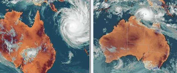
Mass evacuations are underway in the northeastern Australian state of Queensland in anticipation of what forecasters expect will be the largest cyclone ever to hit the continent. Yasi has intensified rapidly and currently has winds gusting up to 295 kilometers per hour (183 mph). It is expected to maintain that intensity—equivalent to a Category Five hurricane on the Saffir-Simpson Scale–until landfall in northeastern Queensland between Cairns and Innisfail during the late evening local time on Feb. 2 (early morning Feb. 2 in the United States).
More information and photos at NASA.
* * *
Cyclone roars toward Australia’s flooded north
MSNBC
1/31/2011
SYDNEY — A strong tropical cyclone roaring toward Australia’s flood-ravaged northeast will likely cause powerful and deadly flash-flooding, officials warned Tuesday, as residents braced for what’s predicted to be one of the fiercest storms the region has ever seen.
Cyclone Yasi was barreling toward the Queensland state coast as a strong Category 3 storm on Tuesday with winds up to 137 mph (220 kph). It was expected to hit the coast Wednesday as a violent Category 4 storm with wind gusts up to 155 mph (250 kph), dumping up to three feet (one meter) of rain on communities already saturated from months of flooding.
“This storm is huge and it is life-threatening,” Queensland Premier Anna Bligh said. “I know many of us will feel that Queensland has already borne about as much as we can bear when it comes to disasters and storms, but more is being asked of us — and I am confident that we are able to rise to this next challenge.”
Yasi would be the second storm to batter Queensland in a week. Cyclone Anthony weakened quickly after hitting land Monday morning, and damage was limited to uprooted trees and downed power lines.
Queensland has already suffered flooding since heavy rains started in November. The floodwaters killed 35 people, damaged or destroyed 30,000 homes and businesses and left Brisbane, Australia’s third-largest city, under water for days.
Yasi is expected to strike farther north and spare Brisbane and towns that have suffered the worst of the recent flooding. Still, Bligh said the storm’s path could change and residents up and down the coast needed to be prepared.
“We could see very powerful flash flooding that will be dangerous and potentially deadly,” said Bligh, who described the storm as one of the largest and most significant cyclones the state has ever seen…
* * *
Good reporting and images at Watts Up With That?
* * *
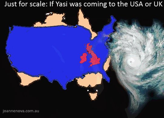
At Twitpic a satellite image of Yasi is compared to other recent cyclones and Hurricane Katrina. When compared to Katrina on that site, it quickly becomes evident what a massive, powerful storm Yasi is.
* * *
Webcam of the approaching Cyclone Yasi due to strike north of Townsville in North Queensland, Australia. Webcam is situated in central T1 Apartments in the CBD of Townsville.
“On the right-Australia’s most destructive cyclone Tracy in 1972 w/winds 250km, Yasi on the left… ” Facebook.com. Click on the photo for a larger view.
Also from Facebook:
Pray, please, for the people of Australia. Queensland is in for a terrible ordeal. They will probably need financial support after this is over and we will be posting links to relief agencies as we can find them.
Update: A reader has sent this link to the Australian Red Cross.


